Service
3D Laser Scanning & Point Cloud Survey
Terrestrial laser scanning and point cloud survey services for buildings, structures, and sites nationwide. We capture geometry with survey-grade scanners and deliver registered point clouds in E57, RCP, LAS, or Revit-ready formats. Fixed-price quotes and fast turnaround from our Brisbane headquarters.
Overview
3D Laser Scanning & Point Cloud Survey explained
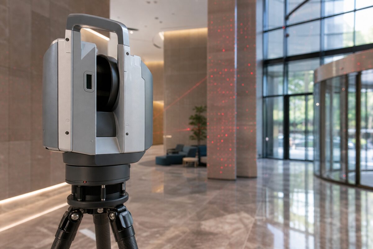
Three-dimensional laser scanning turns a physical building, structure, or site into a precise digital point cloud. We run a full suite of platforms so the method matches the job: the Trimble X7 self-levelling scanner for high-accuracy interiors and structures, the Trimble X9 for longer-range and external work, the NavVis MLX mobile scanner for rapid coverage of large floor plates, and the DJI Matrice 4T for aerial capture. The output is a registered point cloud you can measure, model, and share, delivered from our Brisbane base with fixed-price quotes and fast turnaround.
The advantage of scanning over traditional survey is density. A total station measures one point at a time, while a scanner records hundreds of thousands of points per second, each as an X, Y, Z coordinate with intensity and colour. That means the deliverable captures the whole surface, not just the points a surveyor chose to shoot. Subtle floor slopes, wall bowing, framing irregularities, and clash conditions are all present in the data, which is exactly what design, engineering, and measurement work depends on.
We handle the project end to end. After scoping your deliverables and accuracy targets, we establish survey control, capture the site with the right combination of terrestrial, mobile, and aerial scanning, then register, clean, and quality-check the data against control. You receive the point cloud in the formats your software needs, plus optional CAD extractions, BIM models, or condition overlays produced from the same dataset. Browser-based viewer links let your whole team explore and measure the scan without specialist software.
Accuracy is specified and reported. The Trimble X7 captures at +/-2mm at 20m, and network registration across a multi-scan project typically holds 3 to 5mm. For control-critical work such as monitoring or setout verification, scans are tied to survey control with total station observations so the datum accuracy matches conventional survey while delivering far more spatial information. Every deliverable ships with a registration accuracy report and a clear statement of the achieved tolerance.
Survey control & accuracy
AHD levels and MGA2020 coordinates
Scans are registered to real-world survey control so the data is fit for design and measurement. We set control with GNSS RTK or total station observations, register the point cloud to MGA2020 coordinates, and reduce levels to the Australian Height Datum (AHD). For setout verification, monitoring, or cadastral-grade work, a registered surveyor on staff oversees the control network. Every project is delivered with a registration accuracy report documenting the datum, control, and residuals.
Capabilities
What we deliver
- Buildings, structures, and sites of any size captured in 3D
- Sub-5mm accuracy suitable for BIM modelling and engineering measurement
- Fast turnaround: point clouds delivered within 3-5 business days
- Fixed-price quotes with no hidden costs or hourly rates
- Data delivered in any format: E57, RCP, LAS, DWG, Revit
- Nationwide coverage with local teams in Brisbane, Sydney, Melbourne, and Perth
- Optional BIM modelling, CAD drawings, and condition assessments from the same data
Equipment Used
Deliverables
- Registered point cloud in E57, RCP, LAS, or LAZ format
- facadeinspect.au browser-based viewer links
- Accuracy report with registration statistics
- CAD extractions (plans, sections, elevations) in DWG
- Meshed 3D models for visualisation or analysis
Technical specifications
The numbers behind the data
- Point accuracy
- +/-2mm at 20m (Trimble X7)
- Scanner range
- Up to 80m (X7), up to 150m (X9)
- Capture rate
- Up to 500,000 points per second
- Network registration
- 3 to 5mm across a multi-scan project
- Mobile capture
- Walking speed, +/-10 to 15mm (NavVis MLX)
- Deliverable formats
- E57, RCP/RCS, LAS/LAZ, PTX, DWG
- Typical turnaround
- 3 to 5 business days
- Datum
- MGA2020 coordinates, AHD levels
Standards & compliance
Standards we work to
Open, vendor-neutral format used for delivery and long-term archive.
Followed where the scan feeds a structured BIM deliverable.
National datum for registering scans to project coordinates.
Vertical datum for levels carried through the point cloud.
Governs presentation of plans, sections, and elevations extracted from the cloud.
Our Process
How we work
Project Scoping
We discuss your deliverable requirements, accuracy targets, and site access constraints. You receive a fixed-price quote covering all fieldwork and processing.
Survey Control & Setup
Control points are established using total station or GNSS to tie scans into your required coordinate system. Target placement is optimised for registration quality.
Scanning
Technicians capture the site using terrestrial and/or mobile scanners depending on accuracy needs and area size. The Trimble X7 self-levels and captures at +/-2mm accuracy at 20m range. The NavVis MLX scans at walking speed for broad coverage.
Registration & Delivery
Scans are registered into a unified coordinate system, cleaned of noise, and checked against survey control. Deliverables are produced to your specification and shared via secure cloud link.
FAQs
Common questions
What is 3D laser scanning and how does it work?
3D laser scanning is a surveying technique that measures the distance from a scanner to surrounding surfaces by emitting a laser pulse and timing the return signal. The scanner rotates rapidly, collecting hundreds of thousands of points per second, each recorded as an X, Y, Z coordinate with intensity and often RGB colour. The result is a point cloud: a dense 3D representation of the scanned environment. Modern scanners like the Trimble X7 achieve +/-2mm accuracy at 20m range and can capture a full 360-degree scan in under 3 minutes. The raw scans from multiple positions are then registered (aligned) into a single coordinate system using overlapping geometry or survey targets.
How much does 3D laser scanning cost in Australia?
Pricing depends on site size, complexity, and required deliverables. As a general guide: a single-room scan with basic point cloud delivery starts around $800-$1,200. A full commercial building (3-4 storeys) typically ranges $3,000-$8,000 for point cloud delivery, or $8,000-$20,000 if BIM modelling is included. Large industrial or infrastructure projects are quoted per day of fieldwork (typically $2,500-$4,000/day) plus processing. We always provide fixed-price quotes after understanding your scope, so there are no surprises. Travel outside Southeast Queensland attracts a mobilisation fee.
What is the difference between terrestrial and mobile laser scanning?
Terrestrial scanning uses a tripod-mounted instrument (like the Trimble X7) that captures from fixed positions with very high accuracy (+/-2mm). Each scan takes 2-3 minutes and covers a 360-degree field of view. Mobile scanning (like the NavVis MLX) is carried or pushed through a space at walking speed, using SLAM algorithms to build the point cloud in real time. Mobile scanning is 5-10x faster for coverage but achieves lower accuracy (typically +/-10-15mm). We often combine both: mobile for general coverage and terrestrial for critical measurement areas.
What file formats do you deliver?
We deliver in whatever format your software requires. Common point cloud formats include E57 (open standard, widely supported), RCP/RCS (Autodesk Revit and ReCap), LAS/LAZ (geospatial standard, compressed), and PTX (legacy format for some engineering software). For CAD deliverables we supply DWG, DXF, or DGN. BIM models are delivered as native Revit (.rvt) or IFC for interoperability. We also provide access to facadeinspect.au, our browser-based point cloud viewer that allows your team to explore the scan data, take measurements, and share annotations without specialist software.
How accurate is 3D laser scanning compared to traditional survey?
Individual point accuracy on the Trimble X7 is +/-2mm at 20m, which is comparable to or better than traditional total station measurements for surface geometry capture. The key advantage is density: a scanner captures millions of points, while a total station measures one point at a time. After registration, network accuracy across a multi-scan project is typically 3-5mm. For control-critical work (monitoring, setout verification), we tie scans to survey control using total station observations, achieving the same datum accuracy as conventional survey while providing far more spatial information.
How long does a 3D scanning project take from start to finish?
Fieldwork duration depends on site size. A typical 1,000m2 commercial floor takes 2-3 hours to scan. A three-storey office building is usually a single day. Large industrial facilities may require 3-5 days of fieldwork. Processing and deliverable production takes 3-10 business days depending on complexity. Simple point cloud delivery is fastest; full BIM modelling takes longer. We provide estimated timelines with every quote and can expedite for urgent projects at additional cost.
Do I need to clear the building before scanning?
No. Our scanners are eye-safe (Class 1 laser) and silent, so scanning can occur with normal building occupancy. Furniture, equipment, and people in the scan are simply captured as part of the point cloud and can be filtered out during processing if needed. However, if you need to see behind large objects (e.g., behind a server rack or heavy machinery), those items would need to be moved or we scan from additional angles. We coordinate with your facilities team to minimise disruption.
Can scanning be done outdoors and in poor weather?
Terrestrial scanners work outdoors in most conditions. Rain, fog, and heavy dust can degrade data quality because water droplets and particles reflect the laser before it reaches the target surface. Light drizzle is usually acceptable; heavy rain requires postponement. Direct sunlight does not affect LiDAR scanners (unlike photogrammetry). Temperature extremes (-10C to +50C) are within operating range for our equipment. For critical outdoor projects, we build weather contingency into the schedule at no extra cost.
What does LiDAR stand for and how does it differ from laser scanning?
LiDAR stands for Light Detection and Ranging. In practice, LiDAR and laser scanning refer to the same underlying technology: a sensor emits laser pulses and measures the time of flight to calculate distance. The term "LiDAR" is more commonly used in airborne and mobile mapping contexts, while "laser scanning" or "terrestrial laser scanning" tends to describe tripod-mounted instruments. Both produce point clouds. The distinction is mostly one of convention rather than technology. At Brisbane Point Cloud, we use all three platforms (terrestrial, mobile, airborne) and select based on project requirements.
When should I choose LiDAR over photogrammetry?
LiDAR is the better choice when you need: measurement in poor lighting or indoors (LiDAR does not depend on ambient light), penetration through vegetation to reach the ground surface (multi-return LiDAR passes through tree canopy), high geometric accuracy for engineering measurement, or rapid capture with minimal post-processing. Photogrammetry is preferred when you need high-resolution visual texture, the subject is well-lit with good surface contrast, or budget is constrained and moderate accuracy is acceptable. Many projects benefit from combining both technologies.
Can LiDAR penetrate vegetation?
Yes. Airborne LiDAR systems record multiple returns per pulse. When the laser passes through gaps in tree canopy, the first return records the canopy top and subsequent returns record mid-storey vegetation and the ground surface beneath. Our DJI Matrice 4T LiDAR payload records up to 3 returns per pulse. Ground penetration rates depend on vegetation density: open eucalypt woodland may yield 60-80% ground returns, while dense rainforest canopy may yield only 10-20%. We assess vegetation density during planning and adjust flight parameters to maximise ground return density.
What is the difference between time-of-flight and phase-shift LiDAR?
Time-of-flight (ToF) LiDAR measures the round-trip travel time of a discrete laser pulse to calculate distance. Phase-shift LiDAR emits a continuous modulated laser beam and measures the phase difference between emitted and returned signals. Phase-shift scanners (like the Trimble X7) achieve higher measurement rates (up to 1 million points per second) and better accuracy at short to medium range (up to 80m). Time-of-flight systems excel at longer ranges (hundreds of metres). Most modern terrestrial scanners use phase-shift technology. Airborne systems typically use discrete-return time-of-flight because of the longer measurement distances.
How is LiDAR data georeferenced?
Georeferencing ties the point cloud to a real-world coordinate system. For terrestrial scanning, we survey control targets with GNSS or total station and use these known coordinates to transform the registered point cloud into the project datum (typically MGA2020 in Australia). For airborne LiDAR, the aircraft carries a GNSS receiver and inertial measurement unit (IMU) that record position and orientation at high frequency. Post-processing combines the LiDAR ranges with the trajectory solution to produce directly georeferenced points. Ground control points provide independent accuracy verification.
Do you provide point cloud survey work in Brisbane?
Yes. Point cloud survey Brisbane work is our main service line. We capture buildings, civil sites, industrial plants and construction areas with terrestrial, mobile or airborne LiDAR, then deliver registered point clouds in E57, RCP, LAS or LAZ formats. For design teams, we can also extract plans, sections, elevations, Revit models and surface data from the same scan.
Industries
Industries we serve with 3d laser scanning & point cloud survey
Construction & Developers
Construction teams need reliable as-built geometry before concrete is poured, before services are closed in, and before handover. Legacy drawings are often wrong. Site changes happen daily. A registered point cloud gives the superintendent, engineer, and BIM coordinator one shared reference that matches what is on site today.
IndustryArchitecture & Design
Renovation and adaptive reuse projects fail when the starting drawings are wrong. Ceiling heights, structural offsets, and services routes discovered on site blow budgets and programmes. Terrestrial LiDAR captures the building as it exists, so your design team works from measured geometry instead of assumptions.
IndustryCivil & Infrastructure
Infrastructure assets need geometry that matches field conditions: bridge soffits, culvert invert levels, road corridors, retaining walls, and drainage networks. Traditional pick-up is slow on complex structures. Laser scanning captures millions of points in hours, giving engineers a complete record for assessment, design, and asset management.
IndustryIndustrial & Resources
Industrial sites change constantly: new racking, relocated equipment, added pipe runs, and expansion bays. Outdated P&IDs and layout drawings create safety and maintenance risk. High-definition scanning captures pipes, steel, equipment, and clearances in one visit, giving operations and engineering teams an accurate digital twin.
IndustryHeritage & Cultural
Heritage fabric cannot be measured with destructive methods. Laser scanning records stone, timber, brick, and decorative detail at millimetre resolution without contact. The resulting point cloud supports conservation plans, grant applications, structural assessment, and careful adaptive reuse design.
IndustryInsurance & Legal
Insurance claims, contract disputes, and defect litigation need an independent, measurable record of building condition. Photographs alone lack scale and completeness. A registered point cloud captures the full scene with date-stamped metadata, giving adjusters, lawyers, and expert witnesses a dataset they can measure repeatedly.
Related Pages
Build the right scanning package
Scan to BIM Modelling
Already have point cloud data? We model it into intelligent Revit or ArchiCAD BIM models at LOD 100 through LOD 400. Walls, floors, columns, MEP services, and structural steel modelled to your BIM execution plan. We accept data from any scanner.
ServicePoint Cloud to CAD
Already have a point cloud? We convert it into accurate 2D CAD drawings: plans, sections, and elevations drafted in DWG, DXF, or DGN. Point cloud to CAD is the as-built drafting workflow for teams who need clean 2D documentation rather than a 3D model. We accept scan data from any scanner.
ServicePoint Cloud Processing
Point cloud processing is the set of computational operations applied to raw 3D scan data to produce clean, registered, and classified datasets ready for analysis and modelling. We handle registration, noise removal, classification, format conversion, and quality assurance.
ServiceDrone 3D Mapping Brisbane
Drone surveying for sites too large, too remote, or too dangerous for ground-based scanning. Our CASA-certified pilots deploy LiDAR and camera payloads for everything from 1-hectare building sites to 100-hectare mine sites.
Locations
Coverage by city
Brisbane is our main base, with scheduled project trips to major Australian cities for larger scanning scopes. For local Brisbane work, see our 3D laser scanning Brisbane hub.
Project Proof
Related scanning case studies
Get a quote for 3d laser scanning & point cloud survey
Tell us about your project and we will provide a fixed-price proposal within one business day.