Industry Application
Topographic Survey Brisbane
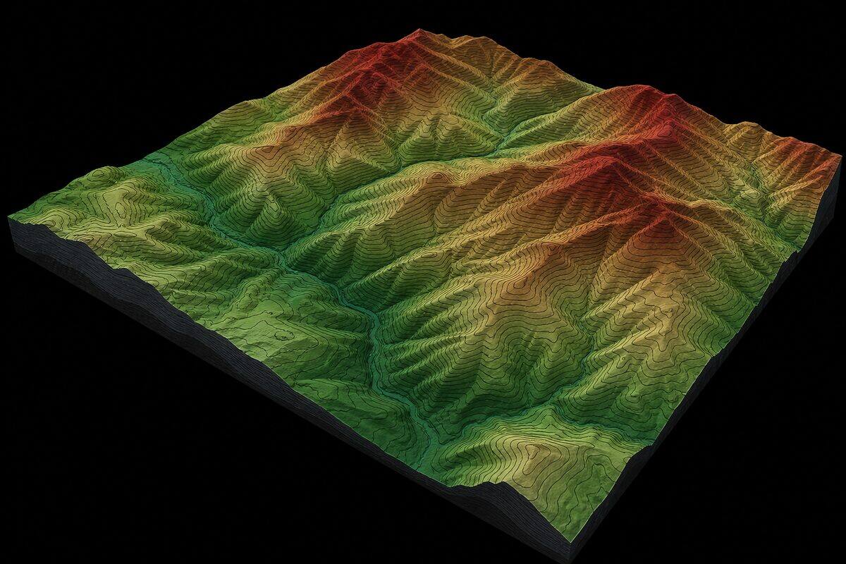
Topographic survey Brisbane civil designers rely on, delivered with airborne LiDAR for subdivision, earthworks and development approval. We produce DTMs, contour plans, cross-sections and cut/fill volumes at +/-30mm vertical accuracy without the weeks of fieldwork traditional survey requires.
Overview
Topographic Survey Brisbane explained
Topographic survey delivers terrain models, contour plans, cross-sections, and earthworks volumes for subdivision, civil design, and development approval. We capture the ground with DJI Matrice 4T aerial LiDAR for broad sites and the Trimble X7 and Trimble X9 for localised detail, then classify, model, and verify the data against control. The result is a detailed digital terrain model at a fraction of the field time traditional total station survey requires, with the density to capture subtle terrain features that spot surveys miss.
The advantage over conventional survey is coverage and detail. A traditional crew measures discrete feature points and interpolates a surface between them; aerial LiDAR records millions of points at 10 to 50cm spacing, producing a far richer terrain model. A twenty-hectare site that would take a two-person crew three to four days can be flown and processed in a single day, and the accuracy is comparable when proper ground control is used. For civil designers this means less time waiting for survey and more terrain detail to design against.
Multi-return LiDAR is the right tool for vegetated land. Because each pulse records several returns, the laser passes through gaps in the canopy and reaches the ground beneath, which photogrammetry cannot do. In open eucalypt forest 40 to 70% of pulses reach the ground; in dense understorey this drops to 10 to 30%, and where penetration is insufficient we supplement with terrestrial scanning along access tracks. Post-processing classifies returns into ground and vegetation so the bare-earth surface is clean.
Deliverables are produced for civil workflows. We generate triangulated and gridded digital terrain models in LandXML, contour plans at any interval from 0.1m to 5m, cross-sections and long-sections at any chainage, and cut, fill, and stockpile volume reports. Breaklines for ridges, kerbs, and drainage are enforced so the surface behaves correctly in design software. Volumes are calculated by comparing surfaces and hold within 1 to 2% for typical sites, formatted for progress claims or regulatory compliance.
Survey control & accuracy
AHD levels and MGA2020 coordinates
Topographic data is tied to ground control for design-grade accuracy. We establish ground control points and independent check points with GNSS RTK, register every flight and scan to MGA2020 coordinates, and reduce levels to the Australian Height Datum (AHD). A registered surveyor on staff oversees control where the survey feeds civil design or development approval. The achieved accuracy is verified against the check points and documented in the survey report, so the terrain model drops into your 12d or Civil 3D project without a manual shift.
Capabilities
What we deliver
- Digital terrain model (DTM) generation from airborne and terrestrial LiDAR
- Contour plan production at any interval (0.1m to 5m)
- Cut/fill volume calculations between existing surface and design
- Cross-section and long-section extraction at any chainage
- Stockpile volume measurement with certified accuracy
- Vegetation-penetrating ground surface extraction using multi-return LiDAR
- Cadastral boundary overlay on terrain data
Equipment Used
Deliverables
- Digital terrain model (DTM) in TIN, grid, or LandXML format
- Digital surface model (DSM) including canopy and structures
- Contour plan (DWG/PDF) at specified interval
- Cross-sections and long-sections (DWG/PDF)
- Volume calculation report (cut, fill, net)
- Georeferenced point cloud (LAS/LAZ) classified to ground
Technical specifications
The numbers behind the data
- Aerial vertical accuracy
- +/-30mm in open terrain at 60 to 80m AGL
- Terrestrial vertical accuracy
- +/-5mm for localised survey
- Point density
- 10 to 50 points/m2
- Contour intervals
- 0.1m to 5m
- Surface formats
- LandXML TIN, gridded DTM/DSM
- Section outputs
- Cross-sections, long-sections (DWG/PDF)
- Volume accuracy
- Within 1 to 2% for typical sites
- Datum
- MGA2020 coordinates, AHD levels
Standards & compliance
Standards we work to
National datum for georeferencing terrain and contour data.
Vertical datum for levels, contours, and cut/fill volumes.
Standard for classified ground point cloud delivery.
Applied where locatable utilities are included in the survey.
Our Process
How we work
Survey Design
We determine the optimal data capture method (aerial LiDAR, terrestrial, or combined) based on site size, vegetation density, accuracy requirements, and terrain complexity. Ground control points are planned.
Ground Control
GNSS RTK is used to establish ground control points and check points across the site. Control density follows standard practice: minimum 5 points for sites under 10 hectares, additional points at 200-300m spacing for larger areas.
Data Capture
Aerial LiDAR is flown at the design height and speed to achieve the required point density (typically 10-50 pts/m2). For smaller sites or areas under dense canopy, terrestrial scanning supplements or replaces the aerial capture.
Surface Generation
The classified ground points are used to build a triangulated irregular network (TIN) or gridded DTM. Breaklines for ridges, valleys, kerbs, and drainage features are enforced. The surface is validated against check points and delivered in your required format.
FAQs
Common questions
How does LiDAR topographic survey differ from traditional total station survey?
Traditional topographic survey measures discrete points one at a time using a total station or GNSS rover. A surveyor selects feature points (top of bank, invert, toe of batter, spot heights on a grid) and the resulting DTM interpolates between these measured points. LiDAR captures millions of points per second without manual point selection, producing a terrain model with point spacing typically 10-50cm. The resulting surface is far more detailed and captures subtle terrain features that spot surveys miss. LiDAR is also faster for large sites: a 20-hectare site that would take a two-person survey crew 3-4 days can be flown and processed in a single day. Accuracy is comparable (both achieve +/-30mm vertical with proper control).
What accuracy does a LiDAR topographic survey achieve?
With ground control points and proper flight parameters, our airborne LiDAR achieves +/-30mm vertical accuracy (RMS) in open terrain at flight heights of 60-80m AGL. In vegetated areas, accuracy depends on canopy density and the proportion of laser returns reaching the ground. For critical engineering applications, we place additional check points in the project area and report achieved accuracy against these independent measurements. Terrestrial LiDAR achieves +/-5mm vertical accuracy for localised terrain surveys. Both methods exceed the requirements of typical civil engineering design (which usually specifies +/-50mm vertical accuracy for preliminary design).
Can you survey through dense vegetation to get ground levels?
Yes, this is one of the key advantages of LiDAR over photogrammetry for topographic survey. Our DJI Matrice 4T records multiple returns per pulse, allowing the laser to pass through gaps in the vegetation canopy and reach the ground. In open eucalypt forest, 40-70% of laser pulses reach the ground. In dense understorey or vine thickets, penetration drops to 10-30%. We assess vegetation density from aerial imagery before flying and adjust parameters accordingly. Where ground penetration is insufficient, we can supplement with terrestrial scanning from below the canopy along access tracks. Post-processing classifies returns into ground and vegetation layers.
What contour intervals can you produce?
We can generate contours at any interval from 0.1m (for detailed engineering design) to 5m (for broad-scale terrain representation). The minimum meaningful interval depends on the survey accuracy: for airborne LiDAR (+/-30mm accuracy), 0.25m contours are the finest practical interval. For terrestrial scanning (+/-5mm), 0.1m contours are achievable. Common requests are 0.5m contours for civil subdivision design, 1m contours for preliminary planning, and 0.25m contours for detailed earthworks and drainage design. All contour plans include spot heights at key terrain features.
How are volumes calculated from LiDAR terrain data?
Volumes are calculated by comparing two surfaces: the existing ground (captured by LiDAR) and either a design surface (from the engineer) or a previous survey (for progress measurement). The software divides the area into a triangulated grid and calculates the vertical difference between surfaces at each point, then integrates across the area to produce cut volume, fill volume, and net volume. For stockpile measurement, we calculate volume above the surrounding ground plane. Accuracy of volume calculations depends on survey accuracy and stockpile geometry; for typical construction stockpiles, we achieve +/-2% volumetric accuracy. Reports are formatted for progress claims or regulatory compliance as required.
Do you provide topographic survey in Brisbane?
Yes. Topographic survey Brisbane work is delivered with drone LiDAR, terrestrial scanning or both depending on the site. Civil designers receive a classified point cloud, DTM, contour plan, cross-sections, long sections and cut/fill volumes tied to project control. Vegetated sites benefit from LiDAR because it can record ground returns through canopy gaps.
Industries
Industries we serve with topographic survey brisbane
Civil & Infrastructure
Infrastructure assets need geometry that matches field conditions: bridge soffits, culvert invert levels, road corridors, retaining walls, and drainage networks. Traditional pick-up is slow on complex structures. Laser scanning captures millions of points in hours, giving engineers a complete record for assessment, design, and asset management.
IndustryConstruction & Developers
Construction teams need reliable as-built geometry before concrete is poured, before services are closed in, and before handover. Legacy drawings are often wrong. Site changes happen daily. A registered point cloud gives the superintendent, engineer, and BIM coordinator one shared reference that matches what is on site today.
IndustryIndustrial & Resources
Industrial sites change constantly: new racking, relocated equipment, added pipe runs, and expansion bays. Outdated P&IDs and layout drawings create safety and maintenance risk. High-definition scanning captures pipes, steel, equipment, and clearances in one visit, giving operations and engineering teams an accurate digital twin.
Related Pages
Build the right scanning package
Drone 3D Mapping Brisbane
Drone surveying for sites too large, too remote, or too dangerous for ground-based scanning. Our CASA-certified pilots deploy LiDAR and camera payloads for everything from 1-hectare building sites to 100-hectare mine sites.
ServiceCivil & Infrastructure
LiDAR surveys for roads, bridges, rail corridors, and civil earthworks. From design verification to as-built documentation, we capture infrastructure at any scale.
ServicePhotogrammetry Services
High-resolution aerial imagery processed into ortho-mosaics, textured 3D meshes, and surface models. Photogrammetry is the image-based alternative to LiDAR: lower cost, full colour, and ideal for visual basemaps, facade documentation, and client presentations.
Service3D Laser Scanning & Point Cloud Survey
Need a building, structure, or site captured in 3D? Our laser scanning service turns physical spaces into precise digital models. We handle everything from quote through to delivery: you get clean, usable point cloud data ready for your software.
Locations
Coverage by city
Brisbane is our main base, with scheduled project trips to major Australian cities for larger scanning scopes.
Project Proof
Related scanning case studies
Get a quote for topographic survey brisbane
Tell us about your project and we will provide a fixed-price proposal within one business day.