Industry Application
Civil & Infrastructure
Precise 3D surveys for roads, bridges, tunnels, rail corridors, and civil earthworks. Our scanning supports design validation, volume calculation, and as-built records.
Overview
Civil & Infrastructure explained
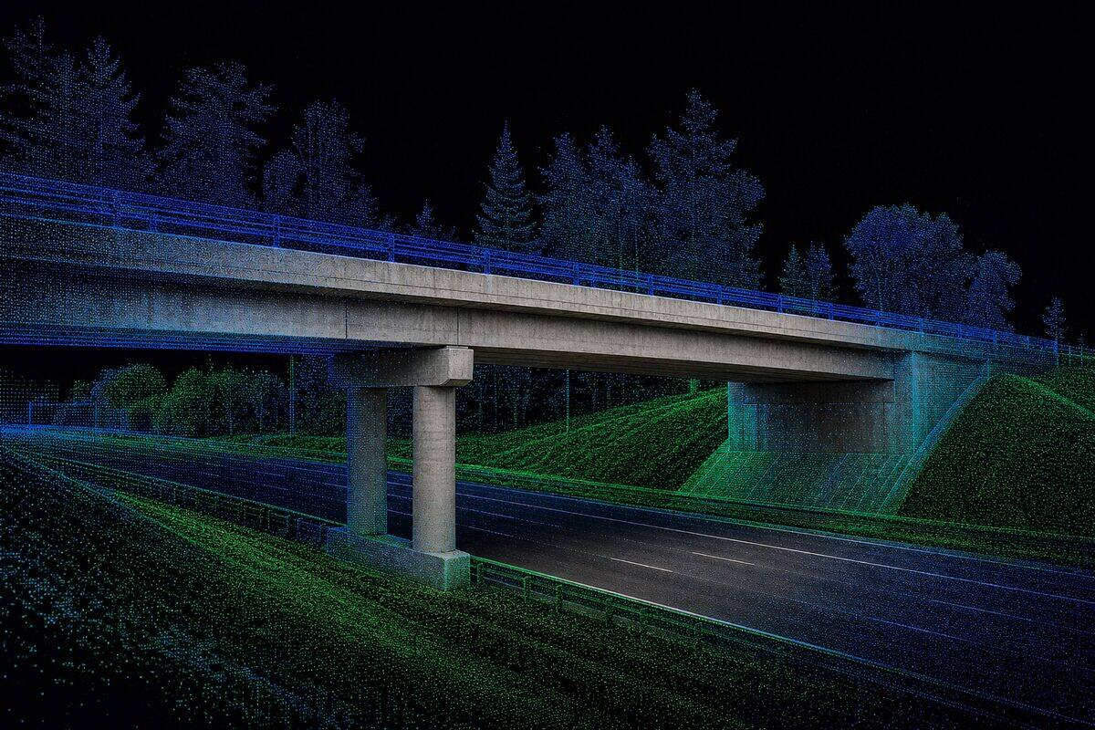
Civil and infrastructure scanning captures roads, bridges, rail corridors, drainage networks, and earthworks at a density traditional pick-up cannot match. We combine the Trimble X7 and Trimble X9 for structures and confined geometry with DJI Matrice 4T aerial LiDAR for corridors and open terrain. The result is a single georeferenced dataset that supports design, condition assessment, volume measurement, and as-built records without sending a survey crew back to site each time a new question comes up.
Engineers need geometry that matches field conditions. Bridge soffits, culvert invert levels, retaining wall alignments, and road cross-falls all drive design and assessment decisions, and all of them are slow and risky to measure by hand on live infrastructure. Laser scanning records millions of points in hours, so the consultant works from a complete surface rather than a sparse set of string-line shots. For corridor projects, drone LiDAR captures the road, batters, drainage, and adjacent terrain in one flight, keeping crews off the carriageway.
Deliverables are produced for the platforms civil teams actually use. We export classified point clouds in LAS and LAZ, triangulated surfaces and digital terrain models in LandXML for 12d and Civil 3D, cross-sections and long-sections in DWG, and volume reports for cut, fill, and stockpiles. Where utilities are part of the scope, locatable services are recorded and labelled to support subsurface utility information workflows. Ortho-mosaic imagery provides a visual basemap that sits underneath the design.
Accuracy is verified, not assumed. Aerial LiDAR achieves +/-30mm vertical in open terrain at standard flying heights, while terrestrial scanning of structures holds +/-2mm at typical ranges. Independent check points placed across the site confirm the achieved accuracy before delivery, and a survey report documents the control, datum, and residuals. This evidence base matters for progress claims, design verification, and regulatory submissions where the numbers have to stand up to scrutiny.
Survey control & accuracy
AHD levels and MGA2020 coordinates
Infrastructure data is only useful if it sits on the right control. We establish or tie into your existing control network with GNSS RTK and total station observations, register every scan and flight to MGA2020 coordinates, and reduce levels to the Australian Height Datum (AHD). A registered surveyor on staff oversees control where the project requires design-grade or asset-register accuracy. Independent check points verify the result, and the survey report records the datum, control marks, and residuals so the data drops straight into your 12d or Civil 3D project without a manual shift.
Capabilities
What we deliver
- Road corridor scanning and surface modelling
- Bridge and overpass structural surveys
- Rail corridor clearance mapping
- Volumetric analysis for earthworks and stockpiles
- Tunnel profiling and deformation monitoring
- Utility and drainage documentation
Equipment Used
Deliverables
- Georeferenced point cloud (LAS, E57)
- Digital terrain model (DTM/DSM)
- Cross-sections and long-sections (DWG)
- Volume calculation reports
- Ortho-mosaic imagery
Technical specifications
The numbers behind the data
- Aerial vertical accuracy
- +/-30mm in open terrain (DJI Matrice 4T)
- Terrestrial point accuracy
- +/-2mm at 20m (Trimble X7)
- Aerial coverage
- 50 to 80 hectares per day with LiDAR
- Surface formats
- LandXML TIN, gridded DTM/DSM
- Point cloud formats
- LAS/LAZ, E57, RCP
- Section outputs
- Cross-sections, long-sections (DWG/PDF)
- Volume accuracy
- Within 1 to 2% for typical earthworks
- Datum
- MGA2020 coordinates, AHD levels
Standards & compliance
Standards we work to
National datum for georeferencing all corridor and structure data.
Vertical datum for levels, surfaces, and cut/fill volumes.
Applied when locatable utilities are mapped within the survey scope.
Open format for point cloud delivery between survey and design software.
Our Process
How we work
Scope & Survey Control
We establish survey control and coordinate datum before capture. Traffic management or rail protection is arranged if required.
Data Capture
Terrestrial scanners and UAV-mounted LiDAR capture the full corridor or structure. We combine ground and aerial data for complete coverage.
Processing & Analysis
Point clouds are classified, filtered, and georeferenced. We generate surface models, cross-sections, and volume calculations from the processed data.
Delivery & Reporting
All deliverables are supplied in your preferred formats with a detailed survey report. We can present directly to your engineering team if needed.
FAQs
Common questions
Can you scan active road corridors?
Yes. We work on active roads regularly and hold current traffic management qualifications. For high-speed roads, we can deploy mobile LiDAR or UAV scanning to minimise lane closures. Lower-speed urban roads are typically scanned with terrestrial LiDAR under rolling traffic control. We coordinate with your traffic management provider or can arrange our own accredited crew depending on the jurisdiction.
How accurate are UAV LiDAR surveys for earthworks volumes?
Our DJI L2 LiDAR payload achieves vertical accuracy of +/-30mm in open terrain at standard flying heights (60-80m AGL). For stockpile and earthworks volume calculations, this translates to volumetric accuracy within 1-2% for typical civil sites. We always place ground control points and check shots to verify accuracy before delivering results. The accuracy is suitable for progress claims, design verification, and regulatory reporting.
What formats do civil engineers typically need?
Most civil engineers work in 12d, Civil 3D, or similar platforms. We commonly deliver georeferenced LAS/LAZ point clouds, TIN surface models in LandXML format, and cross-sections in DWG. For GIS workflows, we can provide GeoTIFF ortho-mosaics and shapefiles. We are flexible and can produce any standard geospatial format your team requires.
Industries
Industries we serve with civil & infrastructure
Civil & Infrastructure
Infrastructure assets need geometry that matches field conditions: bridge soffits, culvert invert levels, road corridors, retaining walls, and drainage networks. Traditional pick-up is slow on complex structures. Laser scanning captures millions of points in hours, giving engineers a complete record for assessment, design, and asset management.
IndustryConstruction & Developers
Construction teams need reliable as-built geometry before concrete is poured, before services are closed in, and before handover. Legacy drawings are often wrong. Site changes happen daily. A registered point cloud gives the superintendent, engineer, and BIM coordinator one shared reference that matches what is on site today.
IndustryIndustrial & Resources
Industrial sites change constantly: new racking, relocated equipment, added pipe runs, and expansion bays. Outdated P&IDs and layout drawings create safety and maintenance risk. High-definition scanning captures pipes, steel, equipment, and clearances in one visit, giving operations and engineering teams an accurate digital twin.
Related Pages
Build the right scanning package
Topographic Survey Brisbane
Terrain models, contour plans, and earthworks volumes delivered from airborne LiDAR. We survey land at 50x the detail of traditional total station methods, penetrate vegetation canopy to map ground level, and produce contours at intervals as fine as 0.25m.
ServiceDrone 3D Mapping Brisbane
Drone surveying for sites too large, too remote, or too dangerous for ground-based scanning. Our CASA-certified pilots deploy LiDAR and camera payloads for everything from 1-hectare building sites to 100-hectare mine sites.
Service3D Laser Scanning & Point Cloud Survey
Need a building, structure, or site captured in 3D? Our laser scanning service turns physical spaces into precise digital models. We handle everything from quote through to delivery: you get clean, usable point cloud data ready for your software.
ServiceConstruction Verification Scanning
Construction verification scanning is the use of 3D laser scanning to compare as-built construction against design models, detecting deviations, verifying setout accuracy, and documenting progress at each construction stage.
Locations
Coverage by city
Brisbane is our main base, with scheduled project trips to major Australian cities for larger scanning scopes.
Project Proof
Related scanning case studies
Get a quote for civil & infrastructure
Tell us about your project and we will provide a fixed-price proposal within one business day.