Service
Photogrammetry Services
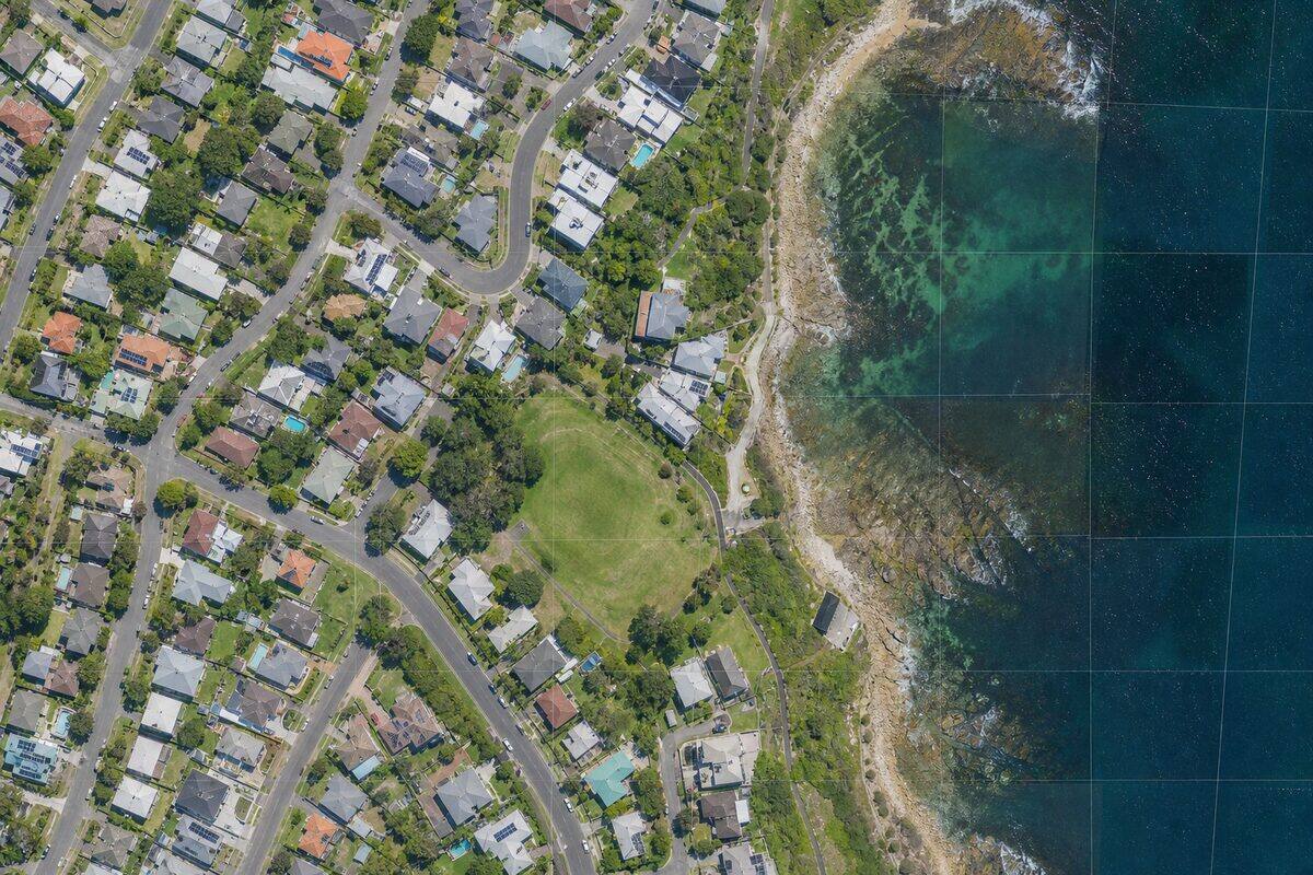
We capture overlapping aerial and close-range photographs, then process them into geo-accurate ortho-mosaics, 3D mesh models, and surface elevations. Ideal when you need visual-quality outputs, colour texture, or a cost-effective alternative to LiDAR.
Overview
Photogrammetry Services explained
Photogrammetry builds 3D measurements from overlapping photographs. We capture imagery with the DJI Matrice 4T and DJI Mini 5 Pro, then process it with structure-from-motion and multi-view stereo into geo-accurate ortho-mosaics, dense point clouds, surface models, and textured meshes. It is the right choice when you need full-colour visual outputs, a cost-effective basemap, or a textured model for presentation, and it pairs naturally with LiDAR on the same flight when both texture and ground penetration are needed.
The strength of photogrammetry is its imagery. Ortho-mosaics give planners, asset managers, and clients a true-to-scale visual record they can interpret without specialist software, and textured meshes communicate a site far better than a bare point cloud. Close-range photogrammetry of facades and monuments captures colour and surface detail at fine resolution, which supports condition assessment and heritage documentation where the look of a surface carries information.
Accuracy is driven by ground sample distance and control. At 60m above ground level the DJI Matrice 4T achieves roughly 1.5cm GSD, and typical aerial photogrammetry resolves positional accuracy at two to three times the GSD. We place a minimum of five ground control points around the site plus independent check points, surveyed with GNSS RTK, so the bundle adjustment is constrained to survey accuracy and the achieved result is verified rather than estimated.
Photogrammetry has limits we are honest about. It needs direct line of sight to surfaces and consistent lighting, so it cannot see the ground under dense canopy and performs poorly in harsh shadow or rain. Where ground topography is needed beneath vegetation, we recommend LiDAR instead or in combination. Choosing the right tool, or the right blend of both, is part of how we scope every job.
Survey control & accuracy
AHD levels and MGA2020 coordinates
Photogrammetric products are tied to survey control through ground control points. We survey GCPs and independent check points with GNSS RTK, constrain the aerotriangulation to MGA2020 coordinates, and reduce surface levels to the Australian Height Datum (AHD). A registered surveyor on staff oversees control where the deliverable feeds design or volume certification. Achieved accuracy is reported against the check points, and all products ship with metadata stating the datum and control used.
Capabilities
What we deliver
- Aerial photogrammetry from UAV platforms at 1-5cm ground sample distance
- Close-range photogrammetry for facades, monuments, and small objects
- Ortho-mosaic production with radiometric correction and seamline editing
- Dense point cloud generation from multi-view stereo matching
- Textured 3D mesh models for visualisation and measurement
- Change detection by comparing multi-epoch image datasets
Equipment Used
Deliverables
- Ortho-mosaic imagery (GeoTIFF, ECW)
- Digital surface model (DSM) and digital terrain model (DTM)
- Dense photogrammetric point cloud (LAS/LAZ)
- Textured 3D mesh (OBJ, FBX, 3D Tiles)
- Volume calculation reports from surface models
Technical specifications
The numbers behind the data
- Ground sample distance
- From 1.5cm at 60m AGL (Matrice 4T)
- Positional accuracy
- Typically 2 to 3 times the GSD
- Image overlap
- 75 to 80% forward, 65 to 70% side
- Ground control
- Minimum 5 GCPs plus check points
- Raster formats
- GeoTIFF, ECW ortho-mosaic; DSM/DTM
- 3D formats
- LAS/LAZ point cloud; OBJ, FBX, 3D Tiles mesh
- Close-range GSD
- 1 to 2mm for facade work at 5 to 10m
- Datum
- MGA2020 coordinates, AHD levels
Standards & compliance
Standards we work to
Framework for reporting horizontal and vertical accuracy of products.
National datum for georeferencing ortho-mosaics and surfaces.
Vertical datum for surface models and derived volumes.
Standard for delivering dense photogrammetric point clouds.
Our Process
How we work
Mission Design
We calculate the required flying height, overlap, and camera settings to achieve your specified ground sample distance. Ground control points are planned for the site geometry.
Image Capture
Our CASA-certified pilots fly the photogrammetry mission with calibrated cameras. Images are captured with 75-80% forward overlap and 65-70% side overlap to ensure full stereo coverage.
Aerotriangulation
Images are aligned using structure-from-motion algorithms. Ground control points constrain the solution to survey accuracy. Bundle adjustment optimises camera positions and lens parameters.
Product Generation
Dense matching produces a 3D point cloud or mesh. Ortho-mosaics, surface models, and volumes are derived from the reconstructed geometry. All products include accuracy metadata.
FAQs
Common questions
What is photogrammetry and how is it different from LiDAR?
Photogrammetry extracts 3D measurements from photographs by identifying common features across multiple overlapping images and triangulating their 3D positions. LiDAR directly measures distance using laser pulses. Key differences: photogrammetry produces high-resolution visual texture (colour imagery) and is generally lower cost for aerial surveys, but requires good lighting and visible surface texture. LiDAR works in any lighting condition, penetrates vegetation, and achieves higher geometric accuracy for engineering measurement. Photogrammetry accuracy depends on ground sample distance (pixel size) and control quality; typical aerial photogrammetry achieves 2-3x GSD accuracy (e.g., 2cm GSD yields 4-6cm positional accuracy).
When should I choose photogrammetry over LiDAR?
Photogrammetry is the better choice when: you need high-resolution visual imagery (ortho-mosaics for planning, marketing, or visual inspection), the site has good surface texture and lighting, moderate accuracy (5-10cm) is acceptable, or budget is a primary constraint. It excels at producing visual basemaps, textured 3D models for client presentations, and facade documentation where colour information matters. LiDAR is preferred for engineering-grade accuracy, vegetation penetration, indoor surveys, or situations requiring measurement in poor lighting. We often recommend combining both on the same UAV flight.
What ground sample distance can you achieve?
Ground sample distance (GSD) depends on flying height and camera sensor. With our DJI Matrice 4T at 60m AGL, we achieve approximately 1.5cm GSD. At 80m AGL, approximately 2cm GSD. The DJI Mini 5 Pro achieves similar GSD at lower heights due to its smaller sensor. For close-range facade photogrammetry, GSD can be as fine as 1-2mm when photographing from 5-10m distance. Finer GSD requires lower flight altitudes, which increases flight time and image count. We recommend the minimum GSD that meets your accuracy and detail requirements to optimise cost.
How many ground control points are needed?
For a standard aerial photogrammetry survey, we place a minimum of 5 ground control points (GCPs) distributed around the site perimeter and centre. Larger sites (over 10 hectares) require additional GCPs at approximately 200-300m spacing. We also place independent check points (not used in processing) to verify achieved accuracy. GCPs are surveyed using GNSS RTK with typical positional accuracy of +/-10mm horizontal and +/-15mm vertical. For projects requiring only relative accuracy (e.g., volume calculations between two epochs), fewer GCPs may be acceptable.
Can photogrammetry work under tree canopy?
No. Photogrammetry requires direct line-of-sight to surfaces. Dense vegetation canopy blocks the camera view of the ground, making it impossible to reconstruct ground surface beneath trees. For vegetated sites where ground topography is needed, LiDAR is the appropriate technology because multiple laser returns can penetrate gaps in the canopy. However, photogrammetry can map the canopy surface itself accurately, which is useful for vegetation height modelling and canopy cover assessment.
What weather conditions are required for photogrammetry?
Photogrammetry requires consistent lighting across all images. Optimal conditions are overcast or uniformly cloudy skies, which provide diffuse lighting without harsh shadows. Direct midday sun creates strong shadows that can confuse matching algorithms and cause artefacts in ortho-mosaics. Rain, fog, and heavy haze degrade image quality and must be avoided. Wind must be within UAV operating limits (typically below 35km/h). We schedule missions for appropriate conditions and reschedule at no cost if weather is unsuitable on the planned day.
Industries
Industries we serve with photogrammetry services
Civil & Infrastructure
Infrastructure assets need geometry that matches field conditions: bridge soffits, culvert invert levels, road corridors, retaining walls, and drainage networks. Traditional pick-up is slow on complex structures. Laser scanning captures millions of points in hours, giving engineers a complete record for assessment, design, and asset management.
IndustryConstruction & Developers
Construction teams need reliable as-built geometry before concrete is poured, before services are closed in, and before handover. Legacy drawings are often wrong. Site changes happen daily. A registered point cloud gives the superintendent, engineer, and BIM coordinator one shared reference that matches what is on site today.
IndustryHeritage & Cultural
Heritage fabric cannot be measured with destructive methods. Laser scanning records stone, timber, brick, and decorative detail at millimetre resolution without contact. The resulting point cloud supports conservation plans, grant applications, structural assessment, and careful adaptive reuse design.
Related Pages
Build the right scanning package
Drone 3D Mapping Brisbane
Drone surveying for sites too large, too remote, or too dangerous for ground-based scanning. Our CASA-certified pilots deploy LiDAR and camera payloads for everything from 1-hectare building sites to 100-hectare mine sites.
Service3D Laser Scanning & Point Cloud Survey
Need a building, structure, or site captured in 3D? Our laser scanning service turns physical spaces into precise digital models. We handle everything from quote through to delivery: you get clean, usable point cloud data ready for your software.
ServiceTopographic Survey Brisbane
Terrain models, contour plans, and earthworks volumes delivered from airborne LiDAR. We survey land at 50x the detail of traditional total station methods, penetrate vegetation canopy to map ground level, and produce contours at intervals as fine as 0.25m.
ServicePoint Cloud Processing
Point cloud processing is the set of computational operations applied to raw 3D scan data to produce clean, registered, and classified datasets ready for analysis and modelling. We handle registration, noise removal, classification, format conversion, and quality assurance.
Locations
Coverage by city
Brisbane is our main base, with scheduled project trips to major Australian cities for larger scanning scopes.
Project Proof
Related scanning case studies
Get a quote for photogrammetry services
Tell us about your project and we will provide a fixed-price proposal within one business day.