Service
Point Cloud Processing
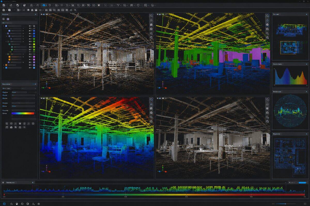
Point cloud processing transforms raw scanner output into usable spatial datasets through registration, cleaning, classification, and format conversion. Brisbane Point Cloud provides processing services for data captured by any scanner brand or platform.
Overview
Point Cloud Processing explained
Point cloud processing is the set of computational steps that turn raw scanner output into clean, registered, classified data ready for analysis and modelling. We take data captured by any scanner brand or platform, including Leica, FARO, Trimble, Riegl, Z+F, NavVis, Matterport, and UAV LiDAR systems, and run it through registration, noise removal, classification, coordinate transformation, and format conversion. If your field team captured the scans but lacks the processing capability or capacity, we take the data from raw through to final deliverable.
Registration is the core of the work. Each scan is captured in its own local reference frame, and registration computes the rotation and translation that aligns overlapping areas into one coordinate system. Poor registration produces doubled surfaces, blurred edges, and positional error that propagates into every downstream measurement. We use target-based registration, cloud-to-cloud refinement, and trajectory-based methods depending on the source, and report registration accuracy as RMS residuals so the quality is documented rather than assumed.
Cleaning and classification make the data usable. We remove noise, multipath artefacts, and stray points without sacrificing fine detail, then classify terrain datasets into ground, vegetation, building, and other categories using progressive filters verified by manual inspection. Coordinate transformations, including MGA94 to MGA2020 and local-to-geodetic conversions, are handled during processing. For very large datasets we tile and index the data so it loads efficiently in CAD, GIS, and web viewers.
Format flexibility is part of the service. We read and write every major standard, including E57, LAS and LAZ, RCP and RCS, PTX and PTS, PLY, and proprietary FARO and Z+F formats, and produce web-ready outputs in 3D Tiles, Potree, and Entwine Point Tiles. Our workstations carry 256GB of RAM with GPU acceleration to handle datasets up to tens of billions of points, and every project ships with a QA report covering registration residuals, classification counts, and check-point analysis.
Survey control & accuracy
AHD levels and MGA2020 coordinates
Processing preserves and verifies the coordinate framework of your data. Where survey targets or control are present, we register and transform the point cloud to MGA2020 coordinates with levels reduced to the Australian Height Datum (AHD), and we perform datum conversions such as MGA94 to MGA2020 on request. Independent check points verify positional accuracy before delivery. A registered surveyor on staff reviews control on projects where the processed data feeds design or cadastral workflows.
Capabilities
What we deliver
- Multi-scan registration using target-based and cloud-to-cloud methods
- Noise filtering and outlier removal without losing fine detail
- Ground classification using progressive morphological filters
- Building, vegetation, and infrastructure class separation
- Format conversion between all major point cloud standards (E57, LAS, RCP, PTX, PTS)
- Coordinate transformation and datum conversion (MGA94 to MGA2020, local to geodetic)
- Point cloud decimation and tiling for large datasets
Equipment Used
Deliverables
- Registered and cleaned point cloud in specified format
- Classification report showing point counts per class
- Registration accuracy report (target residuals, cloud-to-cloud statistics)
- Tiled dataset for large-area projects (compatible with Potree, Cesium, or 3D Tiles)
- Quality assurance documentation with check-point analysis
Technical specifications
The numbers behind the data
- Input sources
- Any scanner brand: Leica, FARO, Trimble, Riegl, Z+F, NavVis, UAV
- Registration accuracy
- 2 to 3mm for terrestrial data
- Classification
- Ground, vegetation, building, other
- Read/write formats
- E57, LAS/LAZ, RCP/RCS, PTX/PTS, PLY, FLS, ZFS
- Web formats
- 3D Tiles, Potree, Entwine Point Tiles
- Dataset scale
- Up to tens of billions of points
- Transformations
- MGA94 to MGA2020, local to geodetic
- QA
- Residuals, class counts, check-point analysis
Standards & compliance
Standards we work to
Open standard read and written for vendor-neutral delivery.
Standard supporting classification and geospatial workflows.
Governs MGA94 to MGA2020 and local-to-geodetic conversions.
Vertical datum carried through transformations and outputs.
Our Process
How we work
Data Ingest
We receive your raw scan data in any format from any scanner manufacturer. Data is inventoried and checked for completeness against the capture log.
Registration
Individual scans or strips are aligned into a unified coordinate system. We use target-based registration, cloud-to-cloud refinement (ICP), or trajectory-based methods depending on the data source. Registration accuracy is reported as RMS residuals.
Cleaning & Classification
Noise points, multipath artefacts, and scanner artifacts are removed. For terrain datasets, points are classified into ground, vegetation, building, and other categories using automated algorithms verified by manual inspection.
Export & QA
The processed dataset is exported in your required format and coordinate system. Independent check-point analysis verifies positional accuracy. A QA report accompanies the final deliverable.
FAQs
Common questions
Can you process data from scanners you did not operate?
Yes. We process point cloud data from any scanner brand or platform: Leica (RTC360, P-series, BLK), FARO (Focus, Orbis), Trimble (X7, X9, TX8), Riegl, Z+F, NavVis, GeoSLAM, Matterport, and UAV LiDAR systems including DJI, Velodyne, and Livox. We work with raw proprietary formats and can register data from multiple scanner types into a single unified point cloud. If your field team captured the data but lacks processing capability, we can take it from raw scans through to final deliverable.
What is point cloud registration and why does it matter?
Registration is the process of aligning multiple individual scans into a common coordinate system. Each scan is captured from a different position, so they initially exist in their own local reference frame. Registration computes the transformation (rotation and translation) that best aligns overlapping scan areas. Poor registration results in doubled surfaces, blurred edges, and positional errors in the final dataset. We achieve registration accuracy within 2-3mm using a combination of surveyed targets and iterative closest point (ICP) refinement. Every project is delivered with a registration accuracy report.
What point cloud formats do you work with?
We read and write all major formats: E57 (open standard, stores intensity and colour), LAS/LAZ (geospatial standard, supports classification), RCP/RCS (Autodesk software), PTX/PTS (ASCII legacy formats), PLY (mesh and point cloud), FLS (FARO proprietary), and ZFS/ZFPRJ (Z+F proprietary). For web-based delivery, we produce 3D Tiles (Cesium), Potree format, and Entwine Point Tiles (EPT). We can convert between any of these formats and handle coordinate system transformations during conversion.
How do you handle very large point cloud datasets?
Large datasets (billions of points, terabytes of data) require spatial indexing, tiling, and often multi-resolution representations. We tile data into manageable spatial blocks (typically 50m or 100m tiles) so that software can load only the required area. For delivery to web viewers, we build octree-based level-of-detail structures that stream progressively. For desktop GIS or CAD use, we provide spatially indexed LAS/LAZ files that load efficiently in software like CloudCompare, RealWorks, or Virtual Surveyor. Our processing workstations have 256GB RAM and GPU acceleration for handling datasets up to 50 billion points.
What quality checks do you perform?
Our QA process includes: registration accuracy check (target residuals must be below specified threshold, typically 3mm for terrestrial data), visual inspection for gaps in coverage, noise analysis (stray points per cubic metre), classification verification (random sampling of classified areas), positional accuracy verification against independent survey check points, and format validation (file opens correctly in specified software). Every project ships with a QA report documenting these checks and their pass/fail status. If any metric fails, we re-process before delivery.
Industries
Industries we serve with point cloud processing
Civil & Infrastructure
Infrastructure assets need geometry that matches field conditions: bridge soffits, culvert invert levels, road corridors, retaining walls, and drainage networks. Traditional pick-up is slow on complex structures. Laser scanning captures millions of points in hours, giving engineers a complete record for assessment, design, and asset management.
IndustryIndustrial & Resources
Industrial sites change constantly: new racking, relocated equipment, added pipe runs, and expansion bays. Outdated P&IDs and layout drawings create safety and maintenance risk. High-definition scanning captures pipes, steel, equipment, and clearances in one visit, giving operations and engineering teams an accurate digital twin.
IndustryConstruction & Developers
Construction teams need reliable as-built geometry before concrete is poured, before services are closed in, and before handover. Legacy drawings are often wrong. Site changes happen daily. A registered point cloud gives the superintendent, engineer, and BIM coordinator one shared reference that matches what is on site today.
Related Pages
Build the right scanning package
3D Laser Scanning & Point Cloud Survey
Need a building, structure, or site captured in 3D? Our laser scanning service turns physical spaces into precise digital models. We handle everything from quote through to delivery: you get clean, usable point cloud data ready for your software.
ServiceScan to BIM Modelling
Already have point cloud data? We model it into intelligent Revit or ArchiCAD BIM models at LOD 100 through LOD 400. Walls, floors, columns, MEP services, and structural steel modelled to your BIM execution plan. We accept data from any scanner.
ServicePoint Cloud to CAD
Already have a point cloud? We convert it into accurate 2D CAD drawings: plans, sections, and elevations drafted in DWG, DXF, or DGN. Point cloud to CAD is the as-built drafting workflow for teams who need clean 2D documentation rather than a 3D model. We accept scan data from any scanner.
ServiceTopographic Survey Brisbane
Terrain models, contour plans, and earthworks volumes delivered from airborne LiDAR. We survey land at 50x the detail of traditional total station methods, penetrate vegetation canopy to map ground level, and produce contours at intervals as fine as 0.25m.
Locations
Coverage by city
Brisbane is our main base, with scheduled project trips to major Australian cities for larger scanning scopes.
Project Proof
Related scanning case studies
Get a quote for point cloud processing
Tell us about your project and we will provide a fixed-price proposal within one business day.