Industry Application
Industrial & As-Built
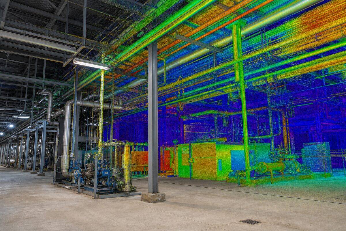
Detailed 3D documentation of industrial facilities, mechanical plant, and process equipment. Our scans capture as-built conditions for retrofit design, maintenance planning, and compliance.
Overview
Industrial & As-Built explained
Industrial and as-built scanning records factories, processing plants, warehouses, and mechanical installations exactly as they are built and operating. We pair the Trimble X7 and Trimble X9 for high-detail capture of plant, pipework, and structural steel with the NavVis MLX mobile scanner to cover large floor plates and long corridors at walking speed. The combined dataset becomes a digital twin that engineering, maintenance, and operations teams use for retrofit design, clash checking, and clearance verification.
Operating sites change constantly. New racking goes in, equipment is relocated, pipe runs are added, and the P&IDs and layout drawings fall behind. That gap creates safety and maintenance risk and makes every expansion project start with a measurement exercise. A single scanning visit captures pipes, valves, supports, steel, equipment, and clearances at once, so the engineering team designs against verified geometry instead of marking up superseded drawings or measuring by tape around live plant.
We model and document to the level the decision requires. Deliverables range from a registered point cloud for your in-house modellers through to as-built CAD drawings, piping layouts with centre-line geometry and outside diameters, and structural steel models. Pipe runs are typically modelled from 50mm diameter and above with accurate routing, fittings, and support locations, which is the detail retrofit clash checking and maintenance planning depend on. Outputs suit AutoCAD Plant 3D, Revit MEP, and Navisworks coordination workflows.
Capture is planned around production. Our scanners are eye-safe Class 1 instruments that do not interfere with electrical or mechanical equipment, so work can proceed during shifts, shutdowns, or maintenance windows where the safety case allows. For large facilities, mobile scanning covers broad areas in minutes while terrestrial scanning handles the critical mechanical zones where millimetre detail matters. All data merges into one unified, registered point cloud with a QA report.
Survey control & accuracy
AHD levels and MGA2020 coordinates
Plant data is registered to a consistent reference so every visit aligns. We scan to your existing plant grid or establish control tied to MGA2020 coordinates with levels reduced to the Australian Height Datum (AHD). Repeat captures register to the same network, which lets us compare scans over time for movement, settlement, or relocation checks. A registered surveyor on staff oversees control where the deliverable feeds setout or asset registers, and every dataset ships with a registration accuracy report.
Capabilities
What we deliver
- Full-facility as-built surveys
- Piping and mechanical equipment documentation
- Structural steel and connection mapping
- Plant layout and clearance verification
- Retrofit and expansion design support
- Digital twin creation for facility management
Equipment Used
Deliverables
- High-density point cloud (E57, RCP)
- As-built CAD drawings (DWG/DXF)
- Piping isometrics and P&ID verification
- facadeinspect.au interactive walkthroughs
- Clash-free 3D models for retrofit design
Technical specifications
The numbers behind the data
- Point accuracy
- +/-2mm at 20m (Trimble X7)
- Mobile capture
- Walking-speed coverage (NavVis MLX)
- Pipe modelling
- Routing, fittings, supports from 50mm diameter
- Point cloud formats
- E57, RCP/RCS, LAS/LAZ
- CAD/BIM output
- DWG/DXF, Revit MEP, AutoCAD Plant 3D
- Large-site method
- Mobile for coverage, terrestrial for detail zones
- Laser safety
- Class 1 eye-safe, no plant interference
- Datum
- Plant grid or MGA2020 coordinates, AHD levels
Standards & compliance
Standards we work to
Governs presentation of as-built CAD drawings and piping layouts.
Applied where a structured BIM handover or digital twin is required.
Open format for delivering plant point clouds between software platforms.
Reference for documenting structural steel members and connections.
Our Process
How we work
Site Induction & Planning
We complete site inductions, review safety requirements, and plan scan positions around operational schedules. Scanning can occur during live operations where safe.
Multi-Scanner Capture
We deploy multiple scanner types to suit the environment: tripod-mounted for precision, mobile for rapid coverage of long corridors and open areas.
Data Integration
Scan data from all instruments is merged into a single coordinate system. We verify registration quality and fill any coverage gaps.
Modelling & Documentation
As-built models, piping layouts, and structural drawings are produced from the scan data. Deliverables are QA-checked against the original point cloud.
FAQs
Common questions
Can you scan while the plant is operating?
In most cases, yes. Our scanners are eye-safe (Class 1) and do not interfere with electrical or mechanical equipment. We work around production schedules and can scan during shifts, shutdowns, or maintenance windows. Certain areas with extreme heat, steam, or explosive atmospheres may require special planning, which we address during the pre-scan consultation. We carry all required PPE and hold current working-at-heights and confined-space tickets.
What level of detail do you capture for piping?
Our terrestrial scanners capture pipe runs down to approximately 15mm diameter. For process plant documentation, we typically model all pipes 50mm diameter and above with accurate routing, fittings, and support locations. Smaller-bore instrument tubing can be modelled on request. Each pipe segment includes centre-line geometry, outside diameter, and insulation thickness where visible. This level of detail supports retrofit clash checking and maintenance planning.
How do you handle large industrial sites?
For large facilities (10,000m2+), we use a combination of mobile scanning for rapid broad coverage and tripod-mounted scanning for high-detail areas. The NavVis MLX captures at walking speed, allowing us to scan an entire warehouse floor in minutes rather than hours. We then deploy the Trimble X7 for critical mechanical areas where sub-millimetre detail is required. All data is merged seamlessly and you receive a single unified point cloud.
Industries
Industries we serve with industrial & as-built
Industrial & Resources
Industrial sites change constantly: new racking, relocated equipment, added pipe runs, and expansion bays. Outdated P&IDs and layout drawings create safety and maintenance risk. High-definition scanning captures pipes, steel, equipment, and clearances in one visit, giving operations and engineering teams an accurate digital twin.
IndustryConstruction & Developers
Construction teams need reliable as-built geometry before concrete is poured, before services are closed in, and before handover. Legacy drawings are often wrong. Site changes happen daily. A registered point cloud gives the superintendent, engineer, and BIM coordinator one shared reference that matches what is on site today.
IndustryCivil & Infrastructure
Infrastructure assets need geometry that matches field conditions: bridge soffits, culvert invert levels, road corridors, retaining walls, and drainage networks. Traditional pick-up is slow on complex structures. Laser scanning captures millions of points in hours, giving engineers a complete record for assessment, design, and asset management.
Related Pages
Build the right scanning package
Point Cloud Processing
Point cloud processing is the set of computational operations applied to raw 3D scan data to produce clean, registered, and classified datasets ready for analysis and modelling. We handle registration, noise removal, classification, format conversion, and quality assurance.
ServicePoint Cloud to CAD
Already have a point cloud? We convert it into accurate 2D CAD drawings: plans, sections, and elevations drafted in DWG, DXF, or DGN. Point cloud to CAD is the as-built drafting workflow for teams who need clean 2D documentation rather than a 3D model. We accept scan data from any scanner.
Service3D Laser Scanning & Point Cloud Survey
Need a building, structure, or site captured in 3D? Our laser scanning service turns physical spaces into precise digital models. We handle everything from quote through to delivery: you get clean, usable point cloud data ready for your software.
ServiceScan to BIM Modelling
Already have point cloud data? We model it into intelligent Revit or ArchiCAD BIM models at LOD 100 through LOD 400. Walls, floors, columns, MEP services, and structural steel modelled to your BIM execution plan. We accept data from any scanner.
Locations
Coverage by city
Brisbane is our main base, with scheduled project trips to major Australian cities for larger scanning scopes.
Project Proof
Related scanning case studies
Get a quote for industrial & as-built
Tell us about your project and we will provide a fixed-price proposal within one business day.